ROADS LESS TRAVELED
![]() We spend a fair amount of time each year traveling on the highways in the United States, Mexico and Canada. Much of that time is in our RV, SUGAR 8, named for us (SUsie & GARy) and our 8th RV in 25 years. That’s another story for another time. This piece is about our choices of routes that changed our feelings about being out here “on the road again”. That is our theme song from Willie Nelson. Here are the lyrics: https://www.youtube.com/watch?v=5v9-InvDwMw
We spend a fair amount of time each year traveling on the highways in the United States, Mexico and Canada. Much of that time is in our RV, SUGAR 8, named for us (SUsie & GARy) and our 8th RV in 25 years. That’s another story for another time. This piece is about our choices of routes that changed our feelings about being out here “on the road again”. That is our theme song from Willie Nelson. Here are the lyrics: https://www.youtube.com/watch?v=5v9-InvDwMw
Early last year we discovered a great way to avoid the heavily traveled and boring interstate highways and instead followed what William Least Heat Moon called Blue Highways. We read his book a long time ago and in our road trips this past year here that is what we did and what we are doing. We generally have a destination in mind regardless how far it is or how long it will take. We do some calculations of distance and start building an itinerary that is not necessarily the shortest or fastest, point to point. We see interesting places, visit family and friends along the way and stay connected to the rest of the world via phone and wifi internet as needed.
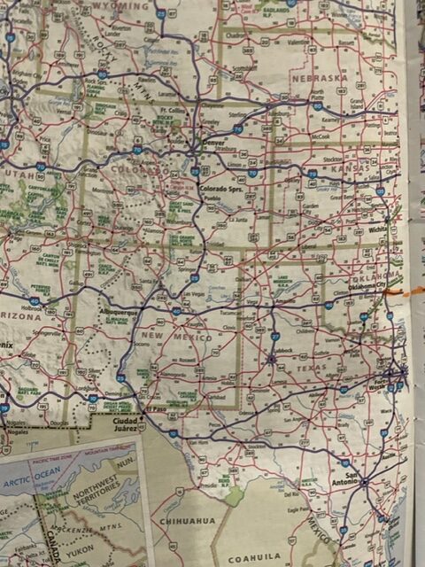
Using a road map, those paper graphics provided by a Road Atlas or a State Highway map, we plot our course of travel in segments on the back country highways and roads, much less traveled and much more scenic and interesting than the straight shot interstate system. We choose roads that go in the same direction, sometimes a parallel highway, sometimes meandering farther afield. Looking at the map, we select a town or city several hours away on those back roads and then plug our desired route into the GPS. We carried a map into a restaurant where a waitress asked us what it was and how did we use it. She confessed she wouldn’t know how to use one but her father did.
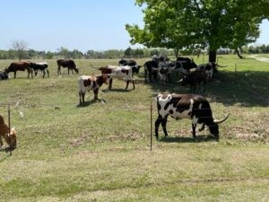
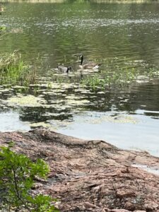
The results: beautiful scenery, through small towns often by-passed and forgotten, some being reclaimed, others looking sad and empty. The countryside landscapes vary with the topography – rivers, lakes, forests, farms and ranches, cattle, sheep, goats and horses, many birds and some wildlife. The Spring wildflowers along the roadsides, in fields and parks, add welcome splashes of color. There is far less stress driving with low volumes of traffic going at a slower speed. If the trip takes a few days longer than it might otherwise, it’s worth the extra time if you have the time. We are blessed with not having to be in one place because of work or other commitments.
We’ve been on the road now for one week, having left our home base in Tubac, Arizona, Wednesday, 4/13, and if all goes according to plan, we will be back there on 4/27, a two-week trip. If you look at the map or can imagine a big circle, avoiding interstates, the route was Tubac to OKC, then to Dallas and now 4 days in 2 TX state parks in the Hill Country between Austin and San Antonio. We will then head toward Santa Fe, NM before heading home. The total mileage will be over 3500 miles with little concern about average speed or mpg. In the past we covered as many as 700 miles in one day, point to point. No more of that! Some days we may go 300 miles, others even less. We arrive relaxed instead of road weary with great appreciation for what we have seen along the way. Here are a few photos. Enjoy!

Comments (2)
Gary: Your post brought back a lot of memories. I learned how to read topographic maps when I was about 10, and was teaching others by the time I was 12. As a biologist type person it was a handy skill to have. I remember one day when my crew was running survey tracts through the forest and we ran into a big load of hematite somewhere. All of a sudden the compass needle turned 90 degrees. Put the compass back in my pocket and brought the crew out 12 feet from the truck. Wouldn’t have been good enough for an orienteering test in college, but in the real world it wasn’t too bad…
I also remember reading, on an RV forum, about a couple who met another couple who were starting their retirement adventures. They met the same couple about three months later, and discovered that the latter pair were getting out of RVing. When asked why, he responded, “It’s the same every day. Get up early, pack up, drive all day, set up camp… At least when I was working I had weekends off.” The thought of staying put or perhaps a relaxing journey apparently never occurred to them.
I really appreciate our GPS, but I refuse to abandon paper maps. There’s an elegance to them, and when you can read a map upside down you know you’re getting somewhere. The most fun is from the map books, where you get to the bottom of page 62 and have to turn to page 115 to continue!
Hugs,
M&M
Fabulous comment, Mike, esp this: ” I refuse to abandon paper maps. There’s an elegance to them, and when you can read a map upside down you know you’re getting somewhere. The most fun is from the map books, where you get to the bottom of page 62 and have to turn to page 115 to continue!” We would do well to teach kids how to read and use all kinds of maps incluing topo maps. I would collect maps we have used but don’t have room. Wait, that gives me an idea about using the highlighter on roads we’ve traveled.