ON THE ROAD – COLUMBIA RIVER
Four days along the Columbia River, 2nd largest in the United States. Named Columbia by Robert Gray, the first to sail across the bar and into the river in 1792. The Mississippi River – 593,000 cubic feet per second. The St. Lawrence River – 348,000 cubic feet per second. … The Columbia River -265,000 cubic feet per second.
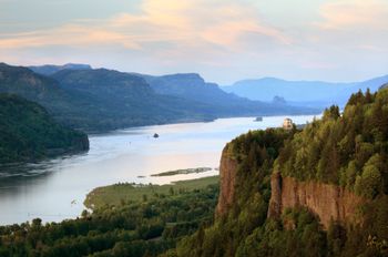
It is breathtaking in its size and its beauty, especially in the canyon (gorge) between the tree-covered mountains on one side in Oregon and on the other side in Washington. It is wide and deep and there are more dams than I imagined. Of the 274 hydroelectric dams in the Columbia River Basin today, 19 are in British Columbia. There are 14 dams on the mainstem Columbia from Mica to Bonneville, and five on the lower Snake from Hells Canyon Dam to Ice Harbor Dam.
When Lewis and Clark and the Corps of Volunteers for Northwestern Discovery crossed into what is now the state of Washington in October 1805, they assumed that the worst part of their journey was behind them. They expected an easy float down the Columbia River to their objective, the Pacific Ocean. Instead, they found a nearly unrelenting series of obstacles, dangers, and annoyances, from life-threatening rapids to inescapable fleas.
The rapids on the Columbia were much bigger and swifter than any they had encountered elsewhere. In the Columbia Gorge, warm air from the arid, treeless plains of eastern Washington collided with cooler air from the west, creating thermal winds of terrific force. Wood was scarce; any driftwood cast ashore by annual spring floods quickly vanished in the campfires of thousands of Indians. Clark reported that people in one village were drying fish and prickly pears to burn as fuel in winter.
On the lower Columbia, the challenges of the river were compounded by the continual irritation of fleas, one legacy of the mild weather and the large population of dogs among the native people. At times, the men could get relief only by stripping naked and getting into the water.
Waterfowl flourished in the marshlands, bringing yet another aggravation. “I [s]lept but verry little last night for the noise Kept [up] dureing the whole of the night by the Swans, Geese, white & Grey Brant Ducks &c. on a Small Sand Island,” Clark wrote at one point (using his distinctive spelling). “…they were emensely noumerous, and their noise horid.”
The closer they got to the Pacific, the more they suffered. This ocean, Clark mused bitterly, was not “pacific” at all, but “tempestuous and horiable.” Storms pinned the party against the rugged, windswept northern coast for weeks. Waves slammed into the mouth of the Columbia with such force that some of the party got seasick. Their leather clothes rotted from the continual soakings, their supplies ran low, and they all got heartily sick of salmon.
On the coast, it rained, drumming a cheerless note in Clark’s journal: “rained all the after part of last night, rain continues this morning…a cool wet raney morning…eleven days rain, and the most disagreeable time I have experenced….” Still, as the expedition prepared to leave its winter headquarters at Fort Clatsop, on the southern (Oregon) side of the Columbia, on March 23, 1806, his tone was conciliatory: “at this place we had wintered and remained from the 7th of Decr. 1805 to this day and have lived as well as we had any right to expect…not withstanding the repeeted fall of rain….”
Two hundred fourteen years later, not much remains unchanged along the Lewis and Clark Trail in Washington. Many of the expedition’s campsites, along with the ancestral villages and fishing grounds of the Indians they met, have been flooded by dams. The plains of eastern Washington now bloom with orchards, vineyards, and other agricultural enterprises, the result of massive irrigation projects. From Clarkston to the coast, the Snake and Columbia Rivers, once muscled with white water, have been turned into a slackwater canal, carrying ocean-going barges more than 400 miles inland. Railroads and freeways slice through lands that once knew only Indian trails.
The wind still blows through the Columbia Gorge, the rain still falls on the Pacific Coast and we experienced this along with plenty of sunshine and loved every minute. Our two stops in the four days were at Cascade Locks, Oregon, across from Stevenson, Washington and in Boardman, Oregon along the banks of the river itself, east of the gorge. We were here the end of June, not in October or March!
![]()
Comments (4)
Before reading your post I can honestly say I knew nothing at all about the Columbia River. Love that I can stop here, catch up on your travels and LEARN! It’s funny, I resist the idea of a road trip but when I look back on my favorite trips of the last decade one that rises to the top? You guessed it – a road trip. Thanks for sharing yours!
Alli
The Columbia River is one of those places because of location where a lot of people here in the States do not visit as it’s so far away from where they are. Is this the lesson? Sometimes we may have to extend ourselves beyond where we thought we could go in order to learn something new, yes?
Stop by anytime and if you learn something from what I’ve shared, I am honored and gratified. I found your reflection on trips of the past decade interesting which started me to think about my own in years gone by, so many years, so many trips. Travel is one of my preferred modes of learning.
Take care, travel well when you can. Thanks!
One of the only areas of the States that I could have seen myself moving to! Super post Gary! Love the photo.
Thanks, Jamie. There are so many beautiful places to see and enjoy and the possibilities are endless. I often entertain a thought when traveling, “How would it be to live here?” Visiting a place and living in a place are very different experiences. One is a snapshot in time, the other is a much longer movie.